Measurement Coordinate System |
  
|
The default coordinate system used by the ![]() Measure command is defined as follows:
Measure command is defined as follows:
•measurements in 3D scene are performed using the global coordinate system of the document;
•measurements of drawing elements belonging to the same drawing view or 2D projection are performed using the coordinate system of such view/projection.
•measurements of drawing elements not belonging to any of the drawing views or 2D projections are performed using the page coordinate system.
•measurements of drawing elements belonging to different drawing views or 2D projection are performed using the common coordinate system via automatic coinciding coordinate systems of such views/projections, so the measured distance between elements is different from the actual distance on drawing page; when measuring relations between an element belonging to a view/projection and an element not belonging to any view/projection, the coordinate system of the view/projection gets coincided with the page coordinate system.
It is often necessary to obtain the characteristics of an element relative to a given coordinate system. For example, when measuring the moment of inertia around given axes. In this case, enable the Measurement Coordinate System checkbox located at the bottom of the Measure section of the command's parameters window. In result, the LCS box appears below the said checkbox and gets automatically activated, so you can select a desired LCS in drawing or 3D scene. When measuring drawing elements, if the object of measurement does belong to a view/projection, while the selected CS doesn't, the measurement is performed using the selected CS after coinciding the CS of the view/projection with the CS of the page.

In order to change the LCS selection, re-activate the LCS box by clicking it with ![]() and then select a different coordinate system. Pressing the
and then select a different coordinate system. Pressing the ![]() Clear button at the right side of the box clears the LCS selection and restores the default coordinate system usage.
Clear button at the right side of the box clears the LCS selection and restores the default coordinate system usage.
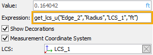
If LCS is specified, the syntax of the function in the Expression field will be changed: instead of get(), there will be get_lcs(), and the specified LCS will be indicated in the expression.

For the distance() and measure() functions, the suffix "_lcs" is not added.
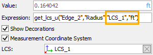
If LCS and units of measurement are specified simultaneously, the function name will be changed according to the addition of LCS and units of measurement: get_lcs_u(). At the same time, the selected LCS and the units of measurement will be indicated sequentially in the comma-separated expression.

In the case of using measure(), the LCS is indicated in the expression before the name of the measured property, and the units of measurement is indicated after, while the suffix "_lcs", as already indicated, is not added.

See Also: